 Loading... Please wait...
Currency Displayed in
- Home
- Maps By Sport
- Canoe Maps Canada
- Southern Indian Lake to Hudson Bay Coast via South Seal River and Seal River (8 Maps) - SYNTHETIC
Categories
Related Products

Southern Indian Lake to Hudson Bay Coast via South Seal River and Seal River (8 Maps) - SYNTHETIC
 - SYNTHETIC")
Hover over image to zoom
 - SYNTHETIC, $239.95 (https://gotrekkers.com/southern-indian-lake-to-hudson-bay-coast-via-south-seal-river-and-seal-river-8-maps-synthetic/))
Product Description
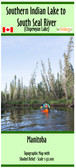
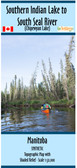
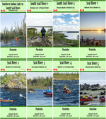
Topographic Map Set from the north end of Southern Indian Lake to the Hudson Bay Coast via South Seal River and Seal River, Manitoba
Scale of 1:50,000 with shaded relief. Contours are in 10m and 50m intervals.
Shows Campsites, rapids information, portages, and helpful advice when using the map.
Includes:
Southern Indian Lake to South Seal River
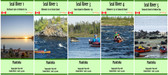
South Seal River 1 - Chipewyan Lake to Porcupine Rapids
South Seal River 2 - Porcupine Rapids to Shethanei Lake
Seal River 1 - Shethanei Lake to Kilometer 60
Seal River 2 - Kilometer 60 to Great Island
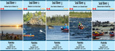
Seal River 3 - Great Island to Kilometer 170
Seal River 4 - Kilometer 170 to Tamarak Island
Seal River 5 - Tamarak Island to Hudson Bay Coast
Maps are printed on synthetic/waterproof paper and comes folded in protective plastic sleeves