 Loading... Please wait...
Currency Displayed in
- Home
- Maps By Sport
- Hiking Maps
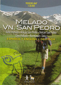
- Melado Volcan San Pedro Chile Trekking Map
Categories
Melado Volcan San Pedro Chile Trekking Map
Product Description
First map of the hiking and riding paradise south of the Maule river: Valle Melado with its San Pedro (3621 m) and San Pablo (3327 m) volcanoes. With level curves each 50 m, hiking routes, thermal baths, campsites and lodgings. GPS compatible. City map of Talca, landscape pictures, drawings of local fauna and a list of recommended service providers.
Trekkingchile, 1st. edition 2010
Trekking Map, Central Chile, scale 1:50,000
English – German - Spanish.


