 Loading... Please wait...
Currency Displayed in
- Home
- Travel Maps
- British Columbia Travel Map
Categories
Related Products
-
 Columbia Travel Map $9.95
 -
-
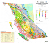
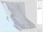 British Columbia Base Map $34.95
 -
-


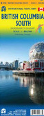
British Columbia Travel Map
 and Victoria (1:20,000), plus a very detailed plan of the Whistler Village with names of hotels, locations of car parks, gondola and chairlift stations, etc. The map is part of the publisher’s series covering Canadian provinces.")
Hover over image to zoom
)
Product Description
Folded road map of British Columbia at a scale of 1;250,000k with small inserts of Victoria & Vancouver.
British Columbia at 1:1,250,000 on an indexed double-sided map from ITMB, with street plans of central Vancouver and Victoria, plus very detailed plan of the Whistler Village. Coverage extends across to Calgary to include the Rocky Mountains with Banff and Jasper National Parks.
The province is divided north/south with a good overlap between the sides. Topography is presented by altitude colouring, with elevation and spot heights given in feet. National and provincial parks and forests are highlighted. The map shows the road network indicating gravel roads and tracks, with driving distances given on main routes and locations of petrol stations marked in more remote areas, particularly in the northern part of the province.
Railway lines and ferry routes are included and local airports are indicated. A range of symbols highlight tourist information offices, camping and RV sites, recreational areas, and other places of tourist interest. The map has a latitude and longitude grid at intervals of 1º and an index of localities.
Also included are street plans of central Vancouver (1:12,500) and Victoria (1:20,000), plus a very detailed plan of the Whistler Village with names of hotels, locations of car parks, gondola and chairlift stations, etc. The map is part of the publisher’s series covering Canadian provinces.