 Loading... Please wait...
Currency Displayed in
- Home
- Maps By Sport
- Hiking Maps
- Aconcagua Trekking map cmc
Categories
Related Products
-
 Aconcagua Trekking map $9.95
 -
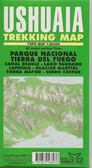 Ushuaia Trekking Map $9.95
 -
 Pucon Trekking Map $9.95
 -

-
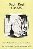 Dudh Kosi Trekking Map $9.95

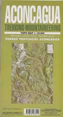
Aconcagua Trekking map cmc

Hover over image to zoom
)
Product Description
Aconcagua on an excellent map combining topographic coverage of the mountain at 1:40,000 and 1:150,000, drawings of south and northwest and east faces, trekking profiles, plans of central Mendoza and Puente del Incas, etc.
On one side is a map of Aconcagua at 1:40,000 with showing routes to the summit. Contours are at 40m intervals, enhanced by relief shading, spot heights, graphics and colouring showing exposed rock, scree, glaciers and crevasses, and shrubbery. Climbing routes to the summit and other tracks are marked. Symbols highlight locations suitable for camping, as well as park officers’ houses, access to drinking water, medical facilities, phone and internet. The map has latitude and longitude grid at intervals of 1’, plus GPS waypoints, with a separate list of GPS coordinates given for the normal and the Polish route to the summit.
The map also includes:
* A contoured trekking map at 1:150,000 covering a wider area and showing trekking routes from the Rio Mendoza valley including access to Plaza Argentina.
* Panorama views of the south, northwest and east faces of Aconcagua highlighting the routes to the summit and accompanied by brief descriptions.
* Route profiles: Puente del Incas to Aconcagua, Confluencia to Plaza Francia, and Punta de Vacas to Plaza Argentina.
* Street plans of central Mendoza and a drawing of Puente del Incas, both highlighting various services.
* Panorama of the mountain showing different vegetation zones, climate charts, historical notes, panorama view of Aconcagua from Cerro Rico, and a drawing of the boulders path at the old Plaza de Mulas.
All the text is in English. Main map legend and route descriptions are also in Spanish, German and French.