 Loading... Please wait...
Currency Displayed in
- Home
- Maps By Sport
- Hiking Maps
- Nootka Island Map
Categories
Related Products
-
 Banks Island map - Folded $39.95
 -
-
-
-
 Island Lake Map $16.50

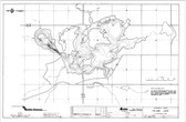
Nootka Island Map

Hover over image to zoom
)
Product Description
A topographic route map for hiking the Nootka Trail on the western shoreline of Nootka Island on the west coast of Vancouver Island, BC
Wild Isle Guide Coastal Hiking Series
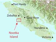
Nootka Island describes a coastal hiking route along the rugged western shoreline of Nootka Island on the west coast of Vancouver Island, BC. The Nootka Trail is marked on a 1:50,000 scale topographic map and includes information on distances and hiking times, recommended campsites, tide cutoffs, sources of drinking water and noteworthy features.
Features:
- customized topographic map
- detailed hiking route
- distances and hiking times
- recommended campsites
- tide cutoffs
- sources of drinking water
- 1 km UTM grid lines
- latitude and longitude
- three-dimensional shaded relief
- covers parts of 92E/10 and 92E/15
Nootka Island is a customized topographic map based on the Canadian NTS Topographic maps and is printed on water-resistant/tearproof synthetic stock.