 Loading... Please wait...
Currency Displayed in
- Home
- Travel Maps
- Jerusalem Travel Map
Categories
Related Products
-
 Victoria Map Travel Map $9.95
 -

-
 Bolivia Map Travel Map $9.95
 -
-

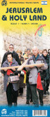
Jerusalem Travel Map

Hover over image to zoom
)
Product Description
Quality Freytag folded map for the city of Jerusalem on a scale of 1:10,000 with comprehensive index, inset map (11”x11”) of the Old City and tourist information. A must have map to buy for any tourist or business visitor travelling to the city of Jerusalem.