 Loading... Please wait...
Currency Displayed in
- Home
- Maps By Sport
- Canoe Maps Canada
- Jasper, AB to Tuktoyaktuk, NWT Canoeing Map Set (23 Maps) - SYNTHETIC
Categories
Related Products
-
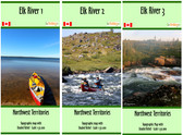 Elk River, NWT Map Set $49.95
 -

-

-
-

Jasper, AB to Tuktoyaktuk, NWT Canoeing Map Set (23 Maps) - SYNTHETIC
 - SYNTHETIC")
Hover over image to zoom
 - SYNTHETIC, $687.95 (https://gotrekkers.com/jasper-ab-to-tuktoyaktuk-nwt-canoeing-map-set-23-maps-synthetic/))
Product Description
A set of annotated topographic maps from Jasper, AB to Tuktoyaktuk, NT with Shaded Relief
The Map set includes
Athabasca River 01 - Jasper to Hinton, 34x19", Scale 1:100,000
Athabasca River 02 - Hinton to Berland Bridge, 41x14", Scale 1:100,000
Athabasca River 03 - Berland River to Whitecourt, 42x16", Scale 1:100,000
Athabasca River 04 - Whitecourt to Klondike Ferry, 42x19", Scale 1:100,000
Athabasca River 05 - Klondike Ferry to Smith, 42x16", Scale 1:100,000
Athabasca River 06 - Smith to Athabasca, 34x23", Scale 1:100,000
Athabasca River 07 - Athabasca to McMillan Lake, 19x41", Scale 1:100,000
Athabasca River 08 - McMillan Lake to House River, 15x41", Scale 1:100,000
Athabasca River 09 - House River to Fort McMurray, 41x19", Scale 1:100,000
Athabasca River 10 - Fort McMurray to Eymundson Creek, 16x41", Scale 1:100,000
Athabasca River 11 - Eymundson Creek to Embarras, 16x41", Scale 1:100,000
Athabasca River 12 - Athabasca-Peace Inland Delta, 27x41", Scale 1:130,000
Slave River 1 - Fort Chipewyan to Hay Camp, 13x42", Scale 1:100,000
Slave River 2 - Hay Camp to Fort Smith, 20x34", Scale 1:100,000
Slave River 3 - Fort Smith to Hook Lake, 16x41", Scale 1:100,000
Slave River 4 - Hook Lake to Fort Resolution, 15x42", Scale 1:100,000
Great Slave Lake South - Fort Providence to Fort Resolution, 41x19", Scale 1:250,000
Mackenzie River 1 - Fort Providence to Fort Simpson, 41x15", Scale 1:250,000
Mackenzie River 2 - Fort Simpson to Johnson River, 22x41", Scale 1:250,000
Mackenzie River 3 - Johnson River to Norman Wells, 15x41", Scale 1:250,000
Mackenzie River 4 - Norman Wells to Ontaratue River, 18x41", Scale 1:250,000
Mackenzie River 5 - Ontaratue River to Tsiigehtchic, 41x18", Scale 1:250,000
Mackenzie River 6 (Mackenzie Delta) - Tsiigehtchic to Tuktoyaktuk, 28x41", Scale 1:250,000
Maps are each folded into a 5x10" plastic sleeve
Printed on synthetic/waterproof paper