 Loading... Please wait...
Currency Displayed in
- Home
- Travel Maps
- Iceland Travel Map
Categories
Related Products
-
 Victoria Map Travel Map $9.95
 -

-

-
 Bolivia Map Travel Map $9.95
 -
 Iceland itmb Travel Map $9.95

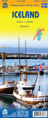
Iceland Travel Map

Hover over image to zoom
)
Product Description
Freytag folded road map of Iceland at 1:400,000 with city map inset for Reykjavik (12"x8"), index, distances in km and colour photos. Best quality travel map that you can buy for your trip to Iceland.
Indexed road map of Iceland at 1:400,000 from Freytag & Berndt with a street plan of central Reykjavik. Numerous large icons boldly highlight various places of interest, campsites and tourist huts, sport and recreational facilities, etc.
Topography is shown by contour at 200m intervals with additional relief shading and spot heights, plus plenty of names of geographical features and clearly marked protected areas.
Road network includes unsurfaced roads and tracks with driving distance on main routes and locations of petrol stations. Local airports and ferry routes are marked. Large icons highlight various places of interest, campsites and youth hostels, mountain refuges and emergency shelters, geysers, waterfalls, viewpoints, etc. The map has a latitude and longitude lines at intervals of 30’. The index, giving postcode numbers for most locations, is on the reverse of the map.
*Multilingual map legend includes English.*