 Loading... Please wait...
Currency Displayed in
- Home
- Maps By Sport
- Ski Tour Maps
- Coquihalla Summit Map
Categories
Related Products
-
 Victoria Map Travel Map $9.95
 -

-
-

-
 Bolivia Map Travel Map $9.95

Coquihalla Summit Map

Hover over image to zoom
)
Product Description
COQUIHALLA SUMMIT
A topographic route map for backcountry skiing and hiking from the Coquihalla Highway in southwestern BC
John Baldwin
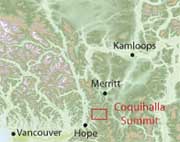
Coquihalla Summit describes backcountry skiing and hiking routes to alpine areas accessible from the Coquihalla Highway 5 in southwestern British Columbia. Routes are marked on a 1:33,300 scale topographic map and include information on ski ascent routes, ski runs, popular names, hiking trails, driving distances and parking areas.
Features:
- customized topographic map
- detailed ski routes
- backcountry ski runs
- hiking trails
- waterproof, tearproof
- table of slope angle relative to contour spacing
- 1 km UTM grid lines
- latitude and longitude
- based on the detailed TRIM maps
- metric base map with 20m contours
Coquihalla Summit is a customized topographic map based on BC Trim Maps.