 Loading... Please wait...
Currency Displayed in
- Home
- Maps By Sport
- Canoe Maps Canada
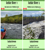
- Geikie River Map Set - SYNTHETIC
Categories
Related Products
-
 Geikie River Map Set $41.95
 -
-
-
-

Geikie River Map Set - SYNTHETIC

Hover over image to zoom
)
Product Description
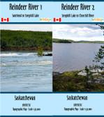
Geikie River Map set (Two Maps)
The maps are 1:50,000 with shaded relief and dimensions of 41.5x10 inches
The maps have rapid descriptions, portages, campsites, inserts for the more complicated rapids, and contour intervals of 10 & 50 meters
The maps are printed on synthetic/waterproof paper and come folded in a protective plastic sleeve