 Loading... Please wait...
Currency Displayed in
- Home
- Maps By Sport
- Canoe Maps Canada
- Bowron Lakes Canoe Circuit Map
Categories
Related Products
-
-
 Manigotagan River Canoe Map $10.00
 -
 Bowron Lakes CD $0.50
 -

-


Bowron Lakes Canoe Circuit Map

Hover over image to zoom
)
Product Description
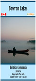
Bowron lakes Canoe Circuit Map, British Columbia
This map has full shaded relief, campsites, trails, roads, latitude/longitude grid/ UTM grid & more. Scale 1:50,000. Size 40"x 26"
The map comes folded and printed on paper in a protective plastic sleeve
Product Videos
6 Day Solo in Bowron Lake Provincial Park BC
-
 6 Day Solo in Bowron Lake Provincial Park BCAfter I finished the season working with an outfitting company...
 -


