 Loading... Please wait...
Currency Displayed in
- Home
- Maps By Sport
- Canoe Maps Canada
- Barker Lake Whitewater Area Map - SYNTHETIC
Categories
Related Products


Barker Lake Whitewater Area Map - SYNTHETIC

Hover over image to zoom
)
Product Description
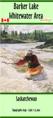
Map of Barker Lake Whitewater Area
The map has the dimensions of 30x19 as is a satellite image of the area
The maps shows all the rapids in the area along with their names and class. It also has the campsites, portages, and composting toliets
This map is printed on synthetic/waterproof paper and comes folded in a protective plastic sleeve.