 Loading... Please wait...
Currency Displayed in
- Home
- Travel Maps
- Slovenia Travel Map
Categories
Related Products
-
-
 Victoria Map Travel Map $9.95
 -

-

-
 Bolivia Map Travel Map $9.95

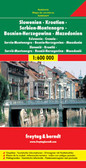
Slovenia Travel Map

Hover over image to zoom
)
Product Description
Freytag double-sided, folded road map of Slovenia at 1:200,000 with attached booklet outlining the top ten sights, city maps for Ljubljana and Maribor, index with postal codes and colour photos. A great quality travel map to buy for your trip to Slovenia.
Slovenia at 1:200,000 from Freytag & Berndt, on a detailed, indexed road map presenting the whole country on one side of the map as an alternative to the publisher’s double-sided version at 1:150,000. Coverage includes the south-eastern corner of Austria with the Carinthian lakes around Klagenfurt and Villach.
Topography is shown by relief shading, with spot heights and plenty of names of peaks, valleys, etc. National parks and protected areas are marked. Road network includes minor roads and cart tracks, and indicates driving distances on most local routes, roads closed to motorized traffic or not recommended for caravans, seasonal closures on mountain roads, steep gradients, toll sections, motorway services, etc. Special tourist routes and scenic roads are highlighted. Railway lines are shown with stations and local airports are marked.
Picturesque towns and villages are highlighted. Symbols mark other places of interest and facilities, including campsites and youth hostels, golf course, museums, etc. The map also highlights the course of long-distance hiking routes across the northern part of the country. Latitude and longitude lines are drawn at intervals of 10’. The index is in a separate booklet attached to the map cover.
*Map legend include English.*
The same cartography, enlarged to 1:150,000 for clearer presentation, is also used in F&B’s “Top 10 Tips” double-side map of Slovenia, with additional tourist information and street plans.