Loading... Please wait...

Categories

Nicaragua El Salvador Travel Map

Hover over image to zoom

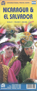
  • Nicaragua at 1:700,000 and El Salvador at 1:250,00 presented together on a double-sided map from ITMB printed on light, waterproof and tear-resistant synthetic paper, with street plans of central Managua, Leon, San Juan del Sur and San Salvador. 

Each country is presented on one side of the map with an index and the relevant street plans. Coverage of Nicaragua also includes insets with Isla de Ometepe (1:180,000) plus the Bid and the Little Corn (Maiz) Islands (1:70,000). 

Topography is shown by altitude colouring, in feet in Nicaragua and in metres in El Salvador, with names of mountain ranges, peaks, etc. National parks and other protected areas are prominently marked. Road network highlights the course of the Pan-American Highway, includes selected local roads, and gives distances on main routes. Railway lines are included and domestic airports are marked. The maps also show internal administrative boundaries with names of the provinces. Symbols highlight various places of interest, including campsites, historical sites, etc. Each map has a latitude and longitude lines at intervals of 30’ and a separate index. 

Street plans are annotated with selected accommodation and other facilities, sights, and in the two capitals, main foreign embassies.
ITMB
$9.95
SKU:
IT0059
Weight:
0.20 KGS

 Product Description

ITMB folded road map of Nicaragua & El Salvador on a scale of 1:700,000 / 1:250,000 with index, colour photos, tourist information and 11"x6" inset of Leon, Managua on waterproof paper. Great map to buy if travelling to Nicaragua & El Salvador.

Nicaragua at 1:700,000 and El Salvador at 1:250,00 presented together on a double-sided map from ITMB printed on light, waterproof and tear-resistant synthetic paper, with street plans of central Managua, Leon, San Juan del Sur and San Salvador. 

Each country is presented on one side of the map with an index and the relevant street plans. Coverage of Nicaragua also includes insets with Isla de Ometepe (1:180,000) plus the Bid and the Little Corn (Maiz) Islands (1:70,000). 

Topography is shown by altitude colouring, in feet in Nicaragua and in metres in El Salvador, with names of mountain ranges, peaks, etc. National parks and other protected areas are prominently marked. Road network highlights the course of the Pan-American Highway, includes selected local roads, and gives distances on main routes. Railway lines are included and domestic airports are marked. The maps also show internal administrative boundaries with names of the provinces. Symbols highlight various places of interest, including campsites, historical sites, etc. Each map has a latitude and longitude lines at intervals of 30’ and a separate index. 

Street plans are annotated with selected accommodation and other facilities, sights, and in the two capitals, main foreign embassies.

 Find Similar Products by Category

You Recently Viewed...


newsletter

Copyright 2025 GoTrekkers. All Rights Reserved.
 Sitemap | Ecommerce Website Design by High Country Web Design.