 Loading... Please wait...
Currency Displayed in
- Home
- Travel Maps
- Netherlands Belgium Travel Map
Categories
Related Products
-
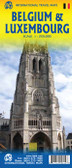
 Belgium Travel Map $9.95
 -
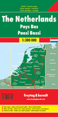 Netherlands Travel Map $9.95
 -
 Victoria Map Travel Map $9.95
 -
-
 Bolivia Map Travel Map $9.95

Netherlands Belgium Travel Map
 / Eindhoven line with a small overlap between the sides.
The map shows the three countries’ road and rail networks, with driving distances marked on main and on selected connecting roads. Symbols highlight various facilities and places of interest, including selected campsites and other tourist accommodation. The map has latitude and longitude lines at intervals of 20’. Each side has a separate index.")
Hover over image to zoom
)
Product Description
This is a double sided map with Netherlands & Belgium on 1 side. The Belgium portion occupies other shared with Luxembourg. The map has two covers, one side saying Belgium and Luxembourg, with a cover picture of a windmill. The map's artwork is completely new and different from the previous edition, and much more in keeping with ITMB's style for Europe. Motorways are in blue, main roads in green, and other roads in red casting. Road distances between points are noted, as well as motorway rest areas, and touristic sites such as windmills, noteworthy churches, and camping areas. Height elevations are minimal, but park areas have been shown. The border portion of France is also included, as well as appropriate border portions of Germany. The 'Low Countries' are very interested for visitors and include canals, historic cities such as Bruges, Leuven, and Liege and the battlefield region of Bastogne and 'The Bulge' this map is also including the West Frisian Islands and adjacent Germany and France with complete index of all cities and towns in the map.
Map size: 27" * 39"
Netherlands with Belgium and Luxembourg at 1:350,000 on an indexed, double- sided map from ITMB. Belgium and Luxembourg are on one side; Netherlands is divided along the Vlissigen (Flushing) / Eindhoven line with a small overlap between the sides.
The map shows the three countries’ road and rail networks, with driving distances marked on main and on selected connecting roads. Symbols highlight various facilities and places of interest, including selected campsites and other tourist accommodation. The map has latitude and longitude lines at intervals of 20’. Each side has a separate index.