 Loading... Please wait...
Currency Displayed in
- Home
- Travel Maps
- Malaysia Travel Map
Categories
Related Products
-
 Victoria Map Travel Map $9.95
 -

-

-
 Bolivia Map Travel Map $9.95
 -
 Malaysia itmb Travel Map $9.95

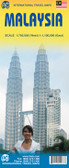
Malaysia Travel Map

Hover over image to zoom
)
Product Description
Freytag double-sided, folded road map of Malaysia (West at 1:600,000 and East at 1:900,000) with tourist information, distances in km & national parks. Best quality map to buy for travelling through Malaysia.
Malaysia on a double-sided, indexed map from Freytag & Berndt, covering both parts of the country at the same scale of 1:900,000; on one side Peninsular Malaysia, with Sarawak and Sabah on the reverse. Very effective relief shading with spot heights and graphics for swamps or mangrove areas and coral reefs provide good representation of the country’s topography.
Road network includes selected local tracks; intermediate distances are given on main routes. Railways, local airports and ferry routes are shown, as well as the country’s internal administrative boundaries with names of the provinces. National parks and other protected areas are highlighted, and icons mark locations of various places of interest, including temples, beaches, caves, etc. The map has a latitude and longitude grid at intervals of 1º and an index. Map legend includes English.