 Loading... Please wait...
Currency Displayed in
- Home
- Maps By Sport
- Canoe Maps Canada
- Nunavut
- Lower Coppermine River Set - Northwest Territories & Nunavut Boundary to Kugluktuk
Categories
Related Products


Lower Coppermine River Set - Northwest Territories & Nunavut Boundary to Kugluktuk

Hover over image to zoom
)
Product Description
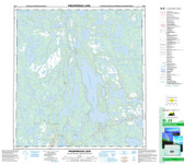
Lower Coppermine River six map set from the Northwest Territories & Nunavut boundary to Kugluktuk
The maps include contours in 10 and 50 metre intervals, shaded relief, rapid descriptions, portages, campsites, and points of interest
They all have a scale of 1:50,000
The dimensions of the maps are:
Lower Coppermine River 1: 41 x 10 inches
Lower Coppermine River 2: 41 x 10 inches
Lower Coppermine River 3: 41 x 10 inches
Lower Coppermine River 4: 41 x 10 inches
Lower Coppermine River 5: 34 x 17 inches
Lower Coppermine River 6: 41 x 10 inches
These maps are printed on paper and come folded in protective plastic sleeves
The maps were made with the help of Ang Harder with AHA Adventures