 Loading... Please wait...
Currency Displayed in
- Home
- Travel Maps
- England Wales itmb Travel Map
Categories
Related Products
-
 Albania itmb Travel Map $9.95
 -
 France itmb Travel Map $9.95
 -
 Turkey itmb Travel Map $9.95
 -
 USA itmb Travel Map $9.95
 -

England Wales itmb Travel Map

Hover over image to zoom
)
Product Description
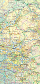
England and Wales Travel Reference MAp 2nd Edition 2015 1:580,000 ISBN 9781553519327 UPC 815534193247 $12.95 cdn/us E8.95 7.99 GBP - ITMB publishes a map of Great Britain, but each portion of GB needs its own map to show roads and attractions in more detail. This is a brilliant map of both England and Wales, showing the entire 'country' in a double-sided format. The place names index is formidable, but England in particular is a series of little villages, so it has been very difficult to decide what to include and what to leave out. This map is showing motorways, divided carriageways, all A & B highways, railway lines, airports, historic sites and touristic attractions, parks and gardens, and just about everything that we could fir on to the page to provide users with a detailed, usable map. We have been able to fit all of southern England/Wales as fair north as Chester/Lincoln on side A and with a little overlap, from those cities north to the well over the Scottish border, up to Perth/Dundee filling side B. The isle of Man and much of Northern Ireland are included as well as a bonus, with an inset map showing the Channel Islands and another in set showing central London. Apologies if we omitted something crucial; please advise. This is a brand new map, replacing the artwork we used in the past. Scotland was done as a double-sided map using the same data base and was released a couple of months ago. This is an excellent map for touring all of England/Wales.