 Loading... Please wait...
Currency Displayed in
- Home
- Travel Maps
- Easter Island Travel Map
Categories
Easter Island Travel Map
Product Description
ITMB folded city map of Santiago in Chile, South America on a scale of 1:12,500 with street index, map inset of the Santiago city region 7``x6`` and Santiago Rapid Transit Guide. Great map to buy when travelling and touring the city of Santiago in Chile, South America.
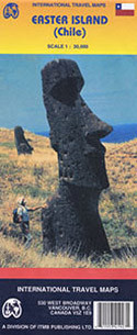
Double-sided map from ITMB combining coverage of the Easter Island at 1:24,000 highlighting locations of its famous statues and selected hotels with, on the reverse, a large, clear, indexed street plan of Santiago with a diagram of the city’s metro network.
On one side is a map of the Easter Island, showing its landscape by altitude colouring with plenty of names of topographic features. Road network includes selected tracks and local trails, with distances shown on main routes and locations of petrol stations. Symbols highlight various places of interest, including statues and platforms, caves, beaches and diving sites, etc. Within Hanga Roa selected hotels are also marked. The map has latitude and longitude lines at 5’ intervals. Surrounding notes provide more information about the island.
On the reverse the central districts of Santiago are presented on an indexed, very clear street plan. Coverage extends beyond Rio Mapocho to include the cable-car link to Estación Pedro de Valdivia, and southwards to the motorway exit onto the Autopista del Sol. Stations of the metro lines are prominently marked, and the map also shows stops of the city’s bus network. For drivers, principal traffic arteries are highlighted and one way streets are marked. Symbols indicate various facilities and places of interest, including selected hotels, shopping centres, embassies, cultural institutions, etc. The map is accompanied by a diagram of the capital’s metro network and a small road map of the environs including access to the international airport and Valparaiso.


