 Loading... Please wait...
Currency Displayed in
- Home
- Maps By Sport
- Hiking Maps
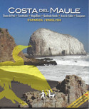
- Costa del Maule Chile Trekking Map
Categories
Costa del Maule Chile Trekking Map
Product Description
The first detailed map of the manifold Maule region's coastline, from Duao to Tregualemu. 1 overview map 1:180,000 and 3 zoom maps of Maguillines & Quebrada Honda / Dunas de Putú / Arcos de Calán, scales from 1:15.000 to 1:40.000. Level curves each 50 m, GPS compatible. With hiking routes (distances in km), offroad tracks, nature attractions and best places for birdwatching.
Coastal bird guide (English/Spanish) with drawings of the 21 most important species. With pictures of the most beautiful attractions.
Trekkingchile, 1st edition 2011
Trekking and Travel Map + Birdwatching, Central Chile – Maule region, scale 1:180,000 / 1:15,00


