 Loading... Please wait...
Currency Displayed in
- Home
- Maps By Sport
- Canoe Maps Canada
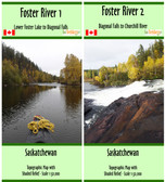
- Foster River Map Set - Lower Foster Lake to Churchill River - SYNTHETIC
Categories
Related Products


Foster River Map Set - Lower Foster Lake to Churchill River - SYNTHETIC

Hover over image to zoom
)
Product Description
Foster River Map Set - Lower Foster Lake to Churchill River is a two map set.
The maps show rapid descriptions, portages, campsites, points of interest, and start locations,
The maps have a scale of 1:50,000 with shaded relief.
The dimensions of the maps are 1: 10x41.5 inches and 2: 27x37 inches
The maps are printed on waterproof/synthetic paper and come folded in protective plastic sleeves