 Loading... Please wait...
Currency Displayed in
- Home
- Maps By Sport
- Hiking Maps
- Chilliwack East map
Categories
Chilliwack East map
Product Description
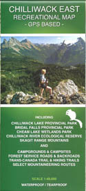
Map of Chilliwack East, BC, Canada, scale 1:40,000.
The first ever accurate GPS-based recreational map of the Chilliwack East (Skagit Range) area including access roads and highways, forest service roads, tracks, trails and mountaineering routes (MR). Roads and trails are qualified to enable best route finding.
Includes Chilliwack Lake Provincial Park, Bridal Veil Falls Provincial Park, Chilliwack River Ecological Reserve, and Cheam Lake Wetlands Regional Park. For camping, hiking, fishing, whitewater kayaking, rafting, paragliding, and mountaineering activities. Also for motorized activities including 4-wheeling, quad riding, and dirt biking.


