 Loading... Please wait...
Currency Displayed in
- Home
- Maps By Sport
- Hiking Maps
- Callaghan Valley map
Categories
Related Products
-
-
 Victoria Map Travel Map $9.95
 -
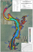 Carawling Valley Lake Map $16.50
 -
 Bolivia Map Travel Map $9.95
 -


Callaghan Valley map

Hover over image to zoom
)
Product Description
This unique map has the most detailed, accurate and up-to-date information available for British Columbia's popular Callaghan Valley area, including the official BC Parks Non-motorized Zones.
This exceptional multi-season map actually contains two maps - the first is a beautifully detailed 1:50,000 scale topo map that includes the Callaghan Valley, the Squamish-Cheakamus Divide, and the Rainbow Mtn / Mt Sproatt areas. The second map (1:30,000 scale) is designed for folks venturing deep into the upper Callaghan Valley area - skiers or hikers.
If you're heading to the Callaghan Valley you'd best bring one of these maps with you - that's what BC Parks ranger do! It's waterproof too, go ahead and use it to keep your butt dry when sitting on wet grass!
Map Features
- Callaghan Lake Provincial Park
- Beautiful Shaded Relief
- Two Maps in One
- Flagged Winter Routes
- Sledder Routes over Powder Mountain
- 25 m Contours
- GPS-Ready: UTM & Lat/Long
- BC Parks Motorized & Non-motorized Zones
- Hike / Traverse Descriptions
- Brew Hut / Tricouni Area
- Trails / Routes / Descents in Callaghan Valley
- Information Guide & Photos
- Waterproof & Tear Resistant