 Loading... Please wait...
Currency Displayed in
- Home
- Historical Maps
- Battle of Normandy michelin
Categories
Related Products
-
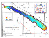 Battle Lake Map $12.95
 -
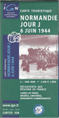 Normandy D Day Map $19.95
 -
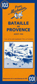 Battle of Provence Map $9.95
 -
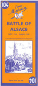 Battle of Alsace Map $9.95
 -

Battle of Normandy michelin
: along the coast from Le Harve and the Seine estuary to the western side of the Cotentin Peninsula and Mont-St-Michel, and inland to include the Falaise – Mortain pocket.
Published two years after the end of the Second World War, the map shows the landing beaches, parachute drop points, early memorial sites, relics of battle such as gun emplacements, areas of significant damage, etc. These details are overlaid on the standard Michelin road map of the day, designed for touring.
An inset illustrates troop movements across the region and the line of attack by various Allied units. Accompanying text provides a brief description of the progress of the battle of Normandy, plus an index of historic names and places of interest highlighted on the map. Map legend and all the text are in English and French.")
Hover over image to zoom
)
Product Description
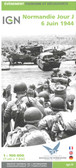
Michelin folded reprinted map from 1947 of the Battle of Normandy June-August 1944 at a scale of 3-15 miles to the inch. Map contains inset of the American and English operations in Normandy, Battle of Normandy historical facts and lists Historical Names and Principal Places of Interest. A super map to buy for anyone interested in the history of this important major Battle.
A reprint of Michelin’s historic 1947 map of Normandy, showing the D-Day Landing sites, the subsequent troop movements, and the battle progressions that established an Allied foothold in the region. Coverage extends beyond the five landing beaches (Utah, Omaha, Gold, Juno and Sword): along the coast from Le Harve and the Seine estuary to the western side of the Cotentin Peninsula and Mont-St-Michel, and inland to include the Falaise – Mortain pocket.
Published two years after the end of the Second World War, the map shows the landing beaches, parachute drop points, early memorial sites, relics of battle such as gun emplacements, areas of significant damage, etc. These details are overlaid on the standard Michelin road map of the day, designed for touring.
An inset illustrates troop movements across the region and the line of attack by various Allied units. Accompanying text provides a brief description of the progress of the battle of Normandy, plus an index of historic names and places of interest highlighted on the map. Map legend and all the text are in English and French.