 Loading... Please wait...
Currency Displayed in
- Home
- Maps By Sport
- Canoe Maps Canada
- Athabasca River 03 - Berland River to Whitecourt
Categories
Related Products


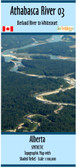
Athabasca River 03 - Berland River to Whitecourt

Hover over image to zoom
)
Product Description
Athabasca River 03 - Berland River to Whitecourt map
The map shows campgrounds, river access points, points of interest, rapids, and helpful information for paddling the river.
The map has a scale of 1:100,000 with shaded relief and has the dimensions of 41.5 x 10 inches
The map is printed on paper and folded into a protective plastic sleeve
Map made with assistance from Paddle Alberta, Mark Lund & Dale Kiselyk