 Loading... Please wait...
Currency Displayed in
Categories
Related Products
-
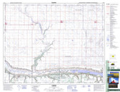
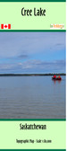 Cree Lake, Saskatchewan Map $24.95
 -
-

-
-
 Saskatchewan Topographic Map $17.00

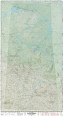
Alex McPhee's Saskatchewan Wall Map - Laminated

Hover over image to zoom
)
Product Description
Alex McPhee's Saskatchewan Wall map is the culmination of over 1,000 hours of data collection and drafting. The final result combines space-age precision with timeless craft. Dozens of data layers show more than any other print map, including every grain elevator, every grid road, every Hutterite colony, every TLE parcel and reserve surrender... Saskatchewan's majestic glacial landscapes aren't really all that flat. See them illuminated in dramatic 3-D by Alex McPhee's own original relief-shading algorithm. It's all about the details, and you'll find plenty in his work. Not commonly seen on other maps: Treaty boundaries, irrigation canals, airfields, the flooded Quill Lakes, community pastures... and even the province's mean centre of population (accurate to 2021). Fall in love with the other half of the province. Digital generalization techniques weren't good enough to properly illustrate the complex Canadian Shield: every creek on the map is hand-drawn! Explore the great North with a comprehensive listing of mines, lodges, and lands.
Printed on cardstock which has been laminated for extra protection. The map is 66"x36". It is shipped rolled.