 Loading... Please wait...
Currency Displayed in
- Home
- Maps By Sport
- Canoe Maps Canada
- Oldman River Map Set - Oldman River Campground to Grand Forks/South Saskatchewan River
Categories
Related Products

Oldman River Map Set - Oldman River Campground to Grand Forks/South Saskatchewan River

Hover over image to zoom
)
Product Description
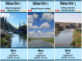
Oldman River Map Set of three maps from Oldman River Campground to Grand Forks/South Saskatchewan River
Includes:
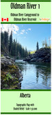
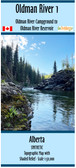
Oldman River 1 - Oldman River Campground to Oldman River Reservoir (1:50,000 + Contours 25/100 intervals, dimensions: 10x44 inches)
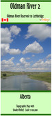
Oldman River 2 - Oldman River Reservoir to Lethbridge (1:100,000 + Contours 10/50 intervals, dimensions: 15x41 inches)
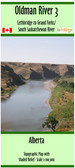
Oldman River 3 - Lethbridge to Grand Forks/ South Saskatchewan River (1:100,000 + Contours 10/50 intervals, dimensions: 10x41 inches)
The maps show campgrounds, river access points with coordinates in UTM and decimal degrees, major rapids, the dam, weirs, and portages.
This map set is printed on paper and comes folded in a protective plastic sleeves.