 Loading... Please wait...
Currency Displayed in
- Home
- Maps By Sport
- Ski Tour Maps
- Kokanee Glacier Provincial Park Ski Routes - SYNTHETIC
Categories
Related Products

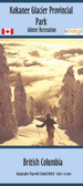

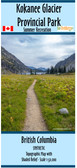

Kokanee Glacier Provincial Park Ski Routes - SYNTHETIC

Hover over image to zoom
)
Product Description
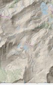
Map of Ski Tour area within Kokanee Glacier Provincial Park winter recreation map, British Columbia. scale 1:10,000 approx. and covers a 10 x 8 km area.
Kokanee Glacier Park winter recreation map from 2009. 2009 Ski Routes are shown for Kokanee Provincial Park produced by BC govt in 2009 & is now out of print. Size 32" x 24", scale was 1:10,000 but will be off due to the resizing of the image. The map does have lat/long & utm grid on it. Map is centered on the Kokanee Glacier Cabin & the Slocan Chief Cabin.
The map is printed on waterproof paper and comes folded in a protective plastic sleeve.