 Loading... Please wait...
Currency Displayed in
- Home
- Maps By Sport
- Canoe Maps Canada
- Hart River - Elliot Lake to Peel River set - SYNTHETIC
Categories
Related Products
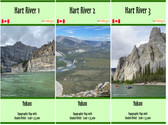


Hart River - Elliot Lake to Peel River set - SYNTHETIC

Hover over image to zoom
)
Product Description
This three map set starts at Elliot Lake and follows Elliot Creek into the Hart River and ends where the Hart River flows into the Peel River on the Peel River 1 map.
The maps have a scale of 1:75,000 with shaded relief and dimensions of 41x10, 41x12, and 41x10 inches
These maps do not include campsite information, rapid descriptions, portages or points of interest.
Printed on synthetic/waterproof paper, the maps come folded in protective plastic sleeves.