Loading... Please wait...

Categories

Guadeloupe Map

Hover over image to zoom

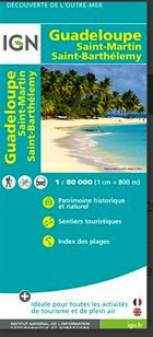
  • Guadeloupe at 1:80,000 from the Institut Gégraphique National in Paris, with street plans of Pointe-à-Pitre and Basse-Terre. Coverage includes the islands of Marie Galante, La Désirade, Iles de la Petite Terre and Les Saintes, plus St. Martin/Sint Maarten and St. Barthélemy shown as insets. 

Topography is presented by relief shading with spot heights, enhanced by colouring and graphic to show woodland, brushwood, mangrove and areas liable to flooding. National parks and protected areas are highlighted. Road network includes cart tracks and local footpaths. Driving distances are indicated on main roads and scenic routes are prominently marked. Also shown are local aerodromes and ferry routes connecting the islands. 

Overprint highlights recommended hiking routes and an extensive range of symbols indicate various tourist facilities including different types of accommodation from holiday villages to campsites and mountain shelters; beeches (with 40 listed as an index) and water sport sites; recreational facilities for horse riding, golf, paragliding, fishing, etc; local markets and handicraft shops, etc. The map has grids both for UTM coordinates and for latitude and longitude at 10’ intervals. Map legend includes English. 

Also provided are coloured aerial photos of Pointe-à-Pitre and Basse-Terre overprinted with names of main streets and selected buildings.
IGN
$14.95
SKU:
IG3x132
Weight:
0.20 KGS

 Product Description

Guadeloupe at 1:80,000 from the Institut Gégraphique National in Paris, with street plans of Pointe-à-Pitre and Basse-Terre. Coverage includes the islands of Marie Galante, La Désirade, Iles de la Petite Terre and Les Saintes, plus St. Martin/Sint Maarten and St. Barthélemy shown as insets. 

Topography is presented by relief shading with spot heights, enhanced by colouring and graphic to show woodland, brushwood, mangrove and areas liable to flooding. National parks and protected areas are highlighted. Road network includes cart tracks and local footpaths. Driving distances are indicated on main roads and scenic routes are prominently marked. Also shown are local aerodromes and ferry routes connecting the islands. 

Overprint highlights recommended hiking routes and an extensive range of symbols indicate various tourist facilities including different types of accommodation from holiday villages to campsites and mountain shelters; beeches (with 40 listed as an index) and water sport sites; recreational facilities for horse riding, golf, paragliding, fishing, etc; local markets and handicraft shops, etc. The map has grids both for UTM coordinates and for latitude and longitude at 10’ intervals. Map legend includes English. 

Also provided are coloured aerial photos of Pointe-à-Pitre and Basse-Terre overprinted with names of main streets and selected buildings.

 Find Similar Products by Category

You Recently Viewed...


newsletter

Copyright 2024 GoTrekkers. All Rights Reserved.
 Sitemap | Ecommerce Website Design by High Country Web Design.